General Publications
 The Enemy in Home Waters: How World War I Came Home to North Carolina The Enemy in Home Waters: How World War I Came Home to North Carolina
When World War I began in 1914, U.S. Navy and American merchant vessels were largely unaffected as the early battles took place far from American shores. All that changed in May 1918, when the German submarine U-151 arrived off the U.S. East Coast, the first foreign enemy naval vessel to invade U.S. waters since the War of 1812. By the end of the war in 1918, three German U-boats, U-151, U-140, and U-117, had sunk a total of 10 vessels off North Carolina.
Graveyard of the Atlantic Report An initial overview of the maritime cultural landscape of the "Graveyard of the Atlantic."
Underwater Cultural Heritage Law Study Report generated by the Department of the Interior, Bureau of Ocean Energy Management and NOAA to provide an analysis of existing laws.
2016 Federal Register Notice for Proposed Boundary Expansion
Monitor 2013 Final Management Plan and Environmental Assessment
Monitor Condition Report (Click here for web version)
Monitor State of the Sanctuary Report
Monitor Brochure
Monitor Fact Sheet
Data Buoy Rack Card (with information on site regulations and permits)
National Marine Sanctuary Program Fact Sheet
Charting a New Course for the Monitor, 1998
A comprehensive long range preservation plan with options for management, stabilization, preservation, recovery, conservation and exhibition of materials and artifacts from the Monitor National Marine Sanctuary.
1983 Management Plan
1982 Management Plan
1975 Federal Register Notice
The original FRN announcing the designation of the Monitor National Marine Sanctuary.
Chronology of the USS Monitor
System map of the Office of National Marine Sanctuaries.
Lesson Plans & Activities
See the Education Section of our website for a wealth of educational resource for both students and teachers.
Dive Slates
Dive slates are created from data collected during an expedition to a shipwreck site. Site surveys and video and photographic data are used to create an accurate representation of the site as it existed at that time. Dive slates may be used for educational purposes or by recreational divers as they enjoy diving on the shipwrecks. To view the current dive slates, visit the Dive Slates web page.
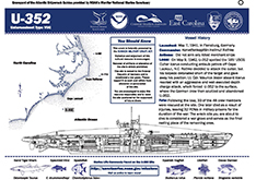
Dive slate for U-352 |
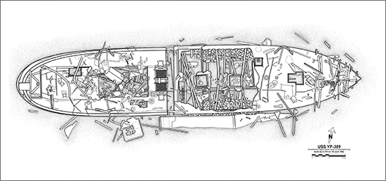
Site Plans
Site plans are archaeological drawings created from data collected during an expedition to a shipwreck site. To view the current site plans, visit the Site Plans web page.
|