Discovery
In early 1953, a group of amateur historians contacted the U.S. Navy and expressed interest in locating and salvaging the Civil War ironclad USS Monitor for establishing the ship as a “national shrine.” Citing a lack of interest in the Monitor other than a historical one, the Navy abandoned all claims to the wreck on Sept. 30, 1953.
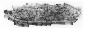
 | | Twenty-one sites are identified as vessels other than the Monitor. Click here for a larger image. (Monitor Collection, NOAA) |
The remains of the Monitor were the object of numerous searches, but lay undiscovered for another 20 years. In 1973, an interdisciplinary team of scientists led by John G. Newton of the Duke University Marine Laboratory proposed testing the usefulness of geological survey equipment for underwater archaeological investigations. The first test of the equipment would be to locate and identify a specific shipwreck, and the only easily identifiable vessel believed to have been lost in the survey area was the USS Monitor.
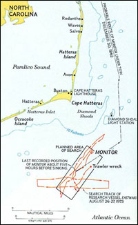
After nearly a year of exhaustive historical research, the scientists narrowed the search region down to an area of high probability where the Monitor likely sank. They developed sonar images and looked for specific patterns, such as the turret, armor belt, and the nearly flat bottom, in those images that would indicate the wreck was the Monitor. The fieldwork took place in August 1973, using the Duke University research vessel Eastward and a remotely operated camera developed by Harold “Doc” Edgerton at MIT. The survey located 22 shipwrecks, two of which exhibited characteristics similar to the Monitor, but no immediate positive identification could be made.
Intensive study of the visual evidence over the next seven months led to a tentative identification of one of the wrecks as the Monitor. The ironclad was difficult to identify, in part because it was lying upside down with its turret, also upside down, separated from the hull and wedged under the port stern. A second visit to the two wrecks in April 1974 confirmed the identification of the Monitor, resting in 230 feet of water approximately 16 miles off Cape Hatteras, N.C.
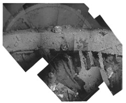
 | | Photo mosaic of the USS Monitor wreck compiled from hundreds of individual 35mm photographs. (Monitor Collection, NOAA) |
During this expedition, scientists also took numerous photographs of the wreck, which the Naval Intelligence Division pieced together to create a photomosaic as an aid to assess the condition of the ship.
Extensive damage to the stern of the wreck was of particular interest. A large portion of the stern armor belt was missing. The propeller and rudder assemblies were present, although further damage to that area was apparent. Scientists who examined the photographic evidence concluded it was unlikely that the sinking alone caused the kind of damage visible at the stern, particularly the destruction of a large section of armor belt. It was also unlikely that natural deterioration could account for the damage.
Conversations with officials in the Navy confirmed that depth charging had taken place during World War II in the area where the Monitor was located. While specific naval documents were classified, enough information was provided by the Navy to suggest that much of the observed damage was probably the result of human activity rather than the sinking or natural deterioration.
| 
 indicates a link leaves the site. Please view our Link Disclaimer | Contact Us | http://monitor.noaa.gov/150th/includes/footer.html


 John G. Newton of the Duke University Marine Laboratory proposed testing the application of geological survey equipment for underwater archaeological survey and assessment. The purpose of the project was to map and study a specific area of the continental shelf off the North Carolina coast. To assess the applicability of the equipment to underwater archaeology, the scientists proposed to locate and identify a specific shipwreck. The only easily identifiable vessel believed to have been lost in the survey area was the USS Monitor.
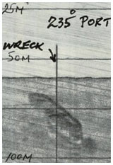 On August 27, the last scheduled day of the expedition, side-scan sonar records a "long amorphous" echo. Three additional days are spent collecting data at the site. Faulty cameras record fuzzy images of a flat surface that appears to be iron plate, and a "circular protrusion" similar to a turret. (Courtesy Monitor Collection, NOAA)