|
Associated Press Coverage
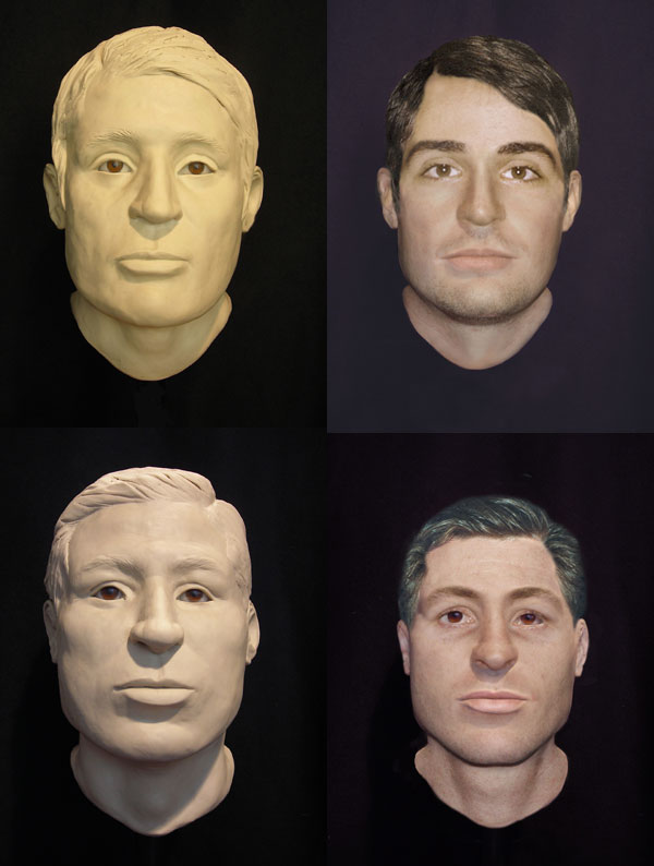
In a longshot bid that combines science and educated guesswork, researchers hope the reconstructed faces of two remains found in the USS Monitor will help someone identify the unknown men. Watch a short video to learn more.
. . . . . . . . . . . .
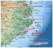
The USS Monitor lies in approximately 240 feet of water just 16 miles south-southeast of Cape Hatteras, N.C. Click here for a larger map. (Courtesy NOAA)
. . . . . . . . . . . .
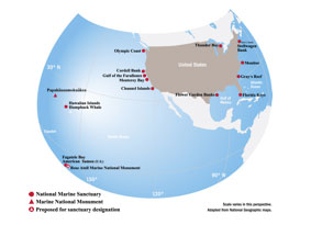 The Monitor National Marine Sanctuary was the first sanctuary of what now includes 14 marine protected areas in U.S. waters. The sanctuary system spans from Thunder Bay in the Great Lakes (the only fresh water sanctuary), to Fagatele Bay in American Samoa. With over 150,000 square miles of America's ocean and Great Lakes waters protected, NOAA's Office of National Marine Sanctuaries works to conserve, protect, and enhance the biodiversity, ecological integrity, and cultural legacy of these special underwater places. (Courtesy NOAA) Click here for a larger map. The Monitor National Marine Sanctuary was the first sanctuary of what now includes 14 marine protected areas in U.S. waters. The sanctuary system spans from Thunder Bay in the Great Lakes (the only fresh water sanctuary), to Fagatele Bay in American Samoa. With over 150,000 square miles of America's ocean and Great Lakes waters protected, NOAA's Office of National Marine Sanctuaries works to conserve, protect, and enhance the biodiversity, ecological integrity, and cultural legacy of these special underwater places. (Courtesy NOAA) Click here for a larger map.
| 
 indicates a link leaves the site. Please view our Link Disclaimer | Contact Us | http://monitor.noaa.gov/150th/includes/footer.html
 John Ericsson (July 31, 1803 – March 8, 1889) was a Swedish-American inventor and mechanical engineer, as was his brother Nils Ericsson.
  Several artifacts were recovered from the immediate area around and under the two sets of skeletal remains found on the Monitor
  Read about expeditions to the Monitor and check out some great photos!